
There come point where a city has to adopt the transport technology that will take it into the future. A bus only public transport solution in canberra is well past its use by date. By 2040 the population of the ACT will be 568,000 people (ABS figures available here). This requires a scalable mass transit technology, and that is light rail.
ACT Light Rail have no preference for the actual location of light rail routes, believing that to be the domain of transport engineers. We are happy to provide speculative routes for consideration. The first tram or light rail routes were proposed for Canberra back in 1912 by Walter Burley Griffin.
Many different routes and schemes have been proposed over the years, but since the 2012 election the ACT Government has selected the Gungahlin to Civic route to begin the light rail network with. It is almost certain that will be extended to Russell.
For more frequent updates on Capital Metro and light rail related news, please visit our Facebook page 'Light Rail for Canberra'.
UPDATE - Light Rail Stage Two Civic to Woden announced by the ACT Government in Sep 2016.
Read:

2016: July 2016 saw the release of the Keeping Canberra Moving report. It had a shortlist of four possible Stage Two routes, arrived after a community consultation process with over 6000 people responding. These were drawn from the 2015 draft Light Rail Network Plan.


2015: The ACT Government release a Light Rail Master Plan. This map was included.

ACT Light Rail have no preference for the actual location of light rail routes, believing that to be the domain of transport engineers. We are happy to provide speculative routes for consideration. The first tram or light rail routes were proposed for Canberra back in 1912 by Walter Burley Griffin.
Many different routes and schemes have been proposed over the years, but since the 2012 election the ACT Government has selected the Gungahlin to Civic route to begin the light rail network with. It is almost certain that will be extended to Russell.
For more frequent updates on Capital Metro and light rail related news, please visit our Facebook page 'Light Rail for Canberra'.
UPDATE - Light Rail Stage Two Civic to Woden announced by the ACT Government in Sep 2016.
Read:
- "Light Rail Stage two - Off to Woden we go" here, covering the announcement
- "Light Rail Stage Two - Civic to Woden" here, with details from Transport Canberra
2016: July 2016 saw the release of the Keeping Canberra Moving report. It had a shortlist of four possible Stage Two routes, arrived after a community consultation process with over 6000 people responding. These were drawn from the 2015 draft Light Rail Network Plan.

2015: The ACT Government release a Light Rail Master Plan. This map was included.
2009: One possible set of light rail routes is not so speculative, as it was included in the official ACT Government bid to Infrastructure Australia.

2009: Another map which is of great interest is this map which was prepared by a consultant to the ACT Government as part of its Sustainable Transport Plan review in 2009. This map shows a possible network in 2031. I would like to see the routes in red as light rail routes, and the other routes as local bus services.

2011: This map was prepared by Katrina Scougall and David Flannery in 2011. Interestingly it shows a Belconnen to Queanbeyan Route as well as a Gungahlin - Civic - Tuggeranng route. You should read the article associated with this map in the Canberra Times.

2008: This map was prepared by an ACT Light Rail member several years ago, and includes a connection to Bungendore and Queanbeyan utilising the existing NSW rail infrastructure, which terminates at the Kingston railway station.

2008: This map was prepared by an ACT Light Rail member several years ago, and includes a connection to Bungendore and Queanbeyan utilising the existing NSW rail infrastructure, which terminates at the Kingston railway station.

2010: The following map was provided by Darryl Johnson, President of the Tuggeranong Community Council.

Back in the early 2000's a proposal for a limited tram line through Civic using historic tram cars was put forward. The 'Federation Line' proposal would run from the War Memorial to the national Museum via Civic. This proposal was obviously tourism focussed and not a serious public transport solution.
There is a brief summary of the proposal online here.

The Federation Line website is still active (although not updated since 2004). I took the following map from their website.

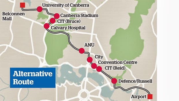
2013: In September 2013, the Canberra Airport proposed a 3 stage light rail extension to the Gungahlin - Civic line. A full analysis of that proposal is here.

Oct 2013 - The Canberra Liberals have a proposal for light rail that they prefer over the Gungahlin to Civic line. Read the Canberra Times article here.
Dec 2014 - The ACT Governments Light Rail Master Plan carried the following map

In reporting on the Light Rail Master Plan, ABC TV Canberra simplified these routes for their viewers:

The Canberra Times in october 1970 had this NCDC proposal for rapid transit

There was a time when a light rail line ran from behind the Deakin shops to all the main centres of Canberra. At the end of World War I, construction of Canberra accelerated. A
network of narrow-gauge railways was built to link the Yarralumla
Brickworks to the main building sites and to the mainline railway
terminus at Kingston.
The map below shows that the main brickworks rail line followed a line that would become Adelaide Avenue to just past Hopetoun Circuit before heading more northward to the Brickworks.
Another line branched south with a loop through Deakin, then back to Yarralumla and around Kintore Crescent to the brickworks.
This Deakin light rail branch was to serve the excavation of valuable white clay in the area of the Deakin Anticline geological site that now lies behind the Deakin shops, between the Soccer Club and The Grange retirement village.
Steam engines pulled the trains, bringing coal, the Deakin clay, and other materials to the Brickworks, then taking finished bricks, tiles and pipes back along Adelaide Avenue, round State Circle, and on to buildng sites at the Hotel Canberra, Old Parliament House, other Parkes buildings including the old Post Office, Kingston, and across the Molonglo valley to Civic.
These construction railways were all pulled up as the initial construction phase of Canberra ended.
The main railway was also extended from Kingston to Bunda Street/Garema Place in Civic, passing through Campbell and Reid, and planned to run up through Braddon as far as Haig Park.

1912 - Walter Burley Griffin’s proposed City Railway of 1912 plotted onto a current Canberra street map, together with the brickworks railway and the Kingston to Civic construction railway.


If you have a historical light rail proposal, please email dchaas67 at gmail dot com
For more frequent updates on Capital Metro and light rail related news, please visit our Facebook page 'Light Rail for Canberra'.